Side of Road and Exposure
For features along single carriageways:
SideOfRoad (values of L or R only) will be determined by position relative to the inventory direction.
Example: on a N-S route, a guardrail on the east side of the carriageway would be coded as R. A parallel feature on the west side would be coded as L.
If the feature has a “face” (e.g., a sign face or billboard), employ a second field (Exposure) to indicate whether the feature “faces” the inventory (I) or non-inventory (N) direction of travel. A third value of other (O) would be used for sign faces that are parallel to the roadway with text facing the roadway (and therefore visible to both directions of travel).
Example: a speed limit sign east of the roadway that faces south on a N-S route would be coded with I since it faces the inventory direction of travel. A passing restriction sign on the west side of the same roadway and also facing south would likewise be coded as I.
NOTE: Side of Road would be in addition to the Orientation field used in 2021 Sign Faces.

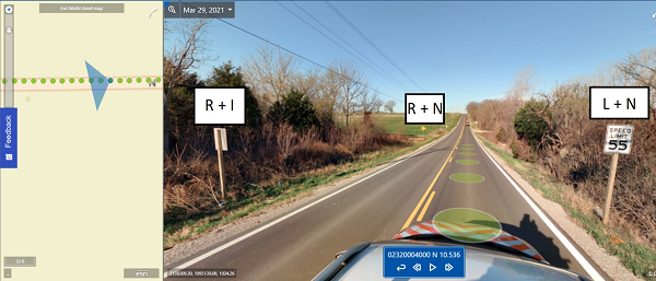
- R + I (Sign face, left center in photo): R = Right side of Inventory Route; I = facing Inventory direction of travel (Exposure).
- R + N (Sign face, center in photo): R = Right side of Inventory Route; N = facing Non-inventory direction of travel (Exposure).
- L + N (Sign face, right center in photo): L = Left side of Inventory Route; N= facing Non-inventory direction of travel (Exposure).
For features along dual carriageways:
SideOfRoad (values of L or R only) will be determined by position relative to the direction of travel (since we can assume all traffic flows the same direction on a carriageway when there are two).
Example: on a E-W route that is split into two carriageways, a paved shoulder on the north side of the south carriageway (going east) would be coded as L. Likewise, a paved shoulder on the south side of the north carriageway (going west) would likewise be coded as L. The “outside” shoulders on each carriageway would be R.
If the feature has a “face” (e.g., a sign face or billboard), employ a second field (Exposure) to indicate whether the feature “faces” the inventory (I) or non-inventory (N) direction of travel. A third value of other (O) would be used for sign faces that are parallel to the roadway with text facing the roadway (and therefore visible to both directions of travel). Even though the SideOfRoad now changes to being relative to direction of travel, we’d still keep this as relative to the inventory direction.
For features that are in the median between two carriageways (like a cable barrier running between them, assuming we include Guardrails in 2023 extraction), they would be tied to the inventory direction only and listed as L for SideofRoad. (Another field, GuardrailLocation in the 2021 data, would continue to be used to indicate that the feature is in the median as opposed to more directly associated with one carriageway.)

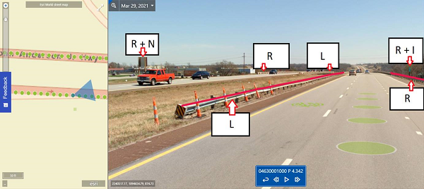
- R + N (Sign face, upper left in photo): R = Right side of Non-Inventory Route; N = facing Non-inventory direction of travel (Exposure).
- R (Guardrail Non-Inventory Route, upper center in photo): R = Right side of Non-Inventory Route; no Exposure for guardrails.
- L (Guardrail Non-Inventory Route, upper center in photo): L = Left side of Non-Inventory Route; no Exposure for guardrails.
- R + I (Milemarker, upper right in photo): R = Right side of Inventory Route; I = facing Inventory direction of travel (Exposure).
- R (Guardrail Inventory Route, upper right in photo): R = Right side of Inventory Route; no Exposure for guardrails.
- L (Guardrail Inventory Route, center in photo): L = Left side of Inventory Route; no Exposure for guardrails.
KDOT makes no warranties, guarantees, or representations for accuracy of this information or any materials that are downloaded and assumes no liability for errors or omissions. In addition, KDOT makes no warranties, guarantees, or representations for the private or public use of any information or materials found on this site, the use of any information or data is at the user’s own risk.

